Sudoor Manthan- IIRS Science Portal
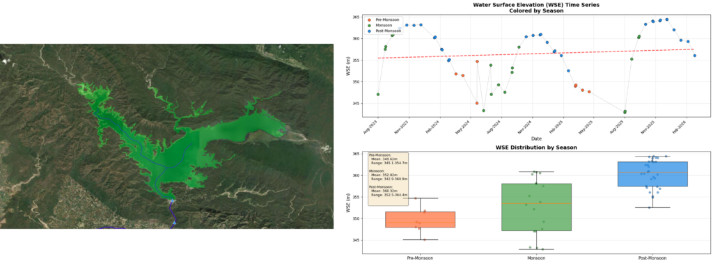
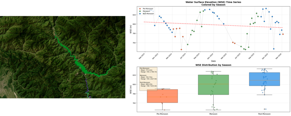
The Ramganga Dam Reservoir and Tehri Dam Reservoir are two important water storage systems in Uttarakhand that support hydropower generation, irrigation, flood control, and drinking water supply. Monitoring these reservoirs using SWOT (Surface Water and Ocean Topography) satellite data helps in understanding their hydrological behaviour, seasonal storage variability, and response to climatic conditions. The reservoirs were selected because they represent contrasting physiographic settings. The Ramganga Dam Reservoir is located in comparatively plain and wider terrain, where water spread is strongly influenced by monsoon inflow, whereas the Tehri Dam Reservoir lies within steep Himalayan terrain, characterized by narrow and elongated water spread controlled by complex topography.
IIRS has developed a web-based system for the near-real time visualisation of data obtained from SWOT for India, the portal was utilised to carry out a comparative analysis of Water Surface Elevation (WSE) for both reservoirs using SWOT satellite observations from August 2023 to February 2026. The observations were classified into pre-monsoon (March–May), monsoon (June–September), and post-monsoon (October–February) periods to assess seasonal and inter-annual variability. The analysis indicates a strong monsoon-controlled hydrological pattern in both reservoirs. Water levels generally rise during and after the monsoon due to rainfall and catchment inflow, while gradual depletion occurs during the pre-monsoon period because of evaporation, reduced inflow, and reservoir utilization. In both systems, the highest WSE values are observed during the post-monsoon months (October–December), indicating delayed recharge and peak storage conditions.
The Ramganga Dam Reservoir exhibits clear seasonal fluctuations with relatively smooth annual recharge and depletion cycles. Statistical analysis of the dataset indicates that the maximum Water Surface Elevation (WSE) was approximately 364.43 m in October 2025, while the minimum WSE was around 342.9 m in July 2025. The overall average WSE during the study period was about 354.43 m, with a total fluctuation range of nearly 21.5 m. The reservoir demonstrates a gradual decline in water levels during the pre-monsoon season, followed by recovery during the monsoon and post-monsoon periods due to rainfall and catchment inflow. The year 2025 recorded the highest seasonal variability, with significant depletion during June (~334.5 m) and rapid recharge leading to peak storage conditions during October–December. The most stable water levels were observed during the post-monsoon months, whereas the strongest fluctuations occurred during May–July. The analysis further suggests that the Ramganga Dam Reservoir, located within comparatively wider terrain and plain regions, experiences gradual storage variations and broader spatial expansion during high-water conditions.
The Tehri Dam Reservoir, situated within steep Himalayan terrain, exhibits comparatively larger and sharper fluctuations influenced by terrain-controlled storage geometry and reservoir regulation. Statistical analysis of the dataset indicates that the maximum Water Surface Elevation (WSE) was approximately 833.40 m in November 2024, while the minimum WSE was around 745.1 m in May 2024. The overall average WSE during the study period was about 790.21 m, with a total fluctuation range of nearly 88.3 m. Significant fluctuations were observed during dry-season reservoir drawdown, particularly during 2024–2025. Some unusually low values, such as 690.41 m in November 2023 and 662.26 m in January 2025, may indicate anomalies or reservoir operational influences. Unlike the Ramganga Dam Reservoir, the Tehri Dam Reservoir is narrow and elongated due to steep valley confinement, resulting in more pronounced elevation variability but relatively constrained lateral expansion.
Overall, both the Ramganga Reservoir and Tehri Dam demonstrate predictable seasonal hydrological behavior, characterized by:
These findings highlight the importance of continuous satellite-based monitoring for reservoir management, hydrological assessment, flood control, and sustainable water resource planning in Uttarakhand.