
Sudoor Manthan- IIRS Science Portal
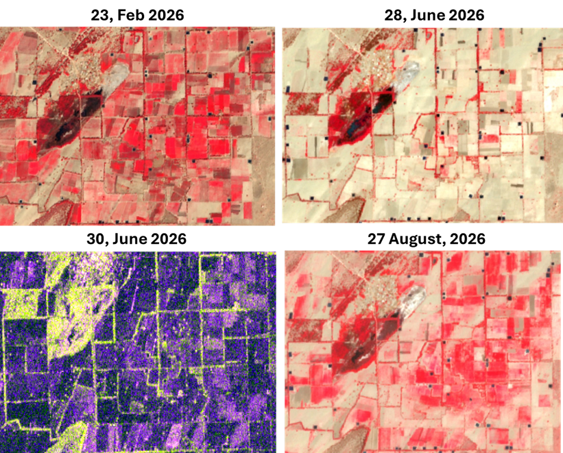
Celebrating one year since its launch, the NASA-ISRO Synthetic Aperture Radar (NISAR) mission leverages dual-frequency (L-band and S-band) polarimetric SAR to map Earth’s land and ice masses every 12 days. This study interprets an aeolian (wind-formed) landscape in and around the Jaisalmer district, Rajasthan, using NISAR L-band SAR imagery acquired on June 30, 2026 (HH, HV, and an RGB composite where Red = HH, Green = HV, Blue = HH/HV). To validate interpretations and track surface transitions from cropped to harvested and tilled stages, the SAR observations are supported by a near-coincident Sentinel-2 False Color Composite (FCC) optical acquisition from June 28, 2026, alongside a multi-temporal optical series from February and April 2026. Across this landscape, the Indira Gandhi Canal acts as a major structural boundary, separating a preserved, natural aeolian environment to the north from an anthropogenically modified agricultural regime to the south.
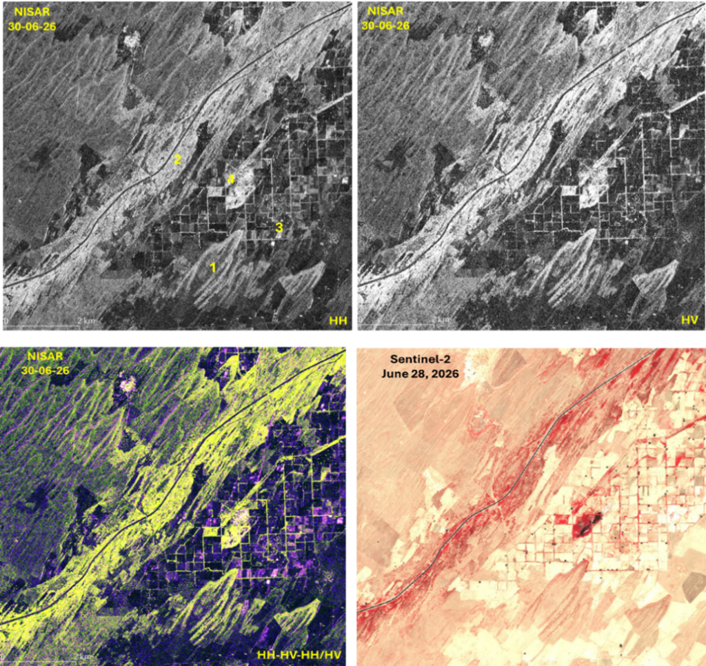
NISAR data very distinctively able to capture the parabolic dunes pointing downwind oriented southwest-to-northeast. Vegetation stabilizes the outer trailing arms, holding them in place (Location-1) while strong winds scoop out the loose, unanchored sand in the middle (a process called blowout) and push the dune nose forward. L-band radar penetrates the dry sand cover to interact with the structural roots and woody stems of vegetation anchored along dune margins, generating enhanced HV volume scattering that vividly outlines their U-shaped forms in the SAR RGB composite. The main canal corridor in central part of image (Location-2) stands out as a bright, continuous yellow ribbon in NISAR RGB and a deep crimson strip in Sentinel-2 FCC, driven by strong HV volume scattering and HH double-bounce scattering from dense tree plantations lining the canal banks. South of the canal, the agricultural landscape (Location-3) in February exhibits intense crimson-red tones in the optical FCC, indicating standing, healthy Rabi crops. In June, representing peak summer, the fields appear freshly ploughed or disked in preparation for the upcoming Kharif monsoon sowing, with secondary soil salinization evident in a few locations as bright white patches in the Sentinel-2 optical FCC. The unploughed, levelled fields after harvest appear pale tan to light yellowish-brown. In NISAR, the ploughed fields (with possible secondary salinization) exhibit high surface roughness that strongly enhances co-polarized HH surface backscatter (Red) over minimal HV volume scattering (Green), appearing distinctly as magenta or light pinkish patches in the SAR RGB composite. The ploughed fields being prepared for crops show signatures of emerging crops in the August data, confirming that the high backscatter observed in June was primarily due to ploughing. Fields without tillage have extremely low backscatter in both HH and HV and appear as dark purple tones. The field boundaries appear as bright lime-green lines due to HV volume scattering from the tree rows (shelterbelts). Towards the NW (Location-4) margin of the agricultural field, an interdunal pond surrounded by vegetation is observed. In the NISAR RGB, the emergent vegetation along the pond triggers strong HH double-bounce scattering, appearing in bright pinkish-magenta tones, whereas the water, having specular reflection, appears dark, and the surrounding vegetation appears bright lime-green due to strong HV volume scattering.
References:
Rosen, P. A., Bawden, G. W., Barela, P., Chapman, B., Fattahi, H., Jones, C. E., Joughin, I. R., Lavalle, M., Lohman, R. B., Simons, M., Siqueira, P., Das, A., Desai, N. M., Kumar, R., Putrevu, D., Sharma, R., & Shrikant, C. V. (2025). The NASA-ISRO SAR (NISAR) mission overview. IEEE Geoscience and Remote Sensing Magazine. https://doi.org/10.1109/MGRS.2025.3578258