Floods in Bihar are a common phenomenon during monsoon seasons starting from June to September. From the analysis of long term in-situ gauge data and historical satellite based observations it is well observed that June marks the onset of flooding which progressively increases in July and August months followed by a declining and progressive recession in flooding from mid-September. Gauge data clearly show that during July end and August month most of the rivers in Bihar are in full spate crossing the danger levels and also breaching the previous highest flood levels. However, there has been a shift observed in regular flooding pattern and August month is witnessing less flooding whereas the month of September is being marked by more pronounced flooding especially towards the end continuing till mid or late October (Bhatt etal., 2020). The 2019 floods of Bihar are one such example when Bihar especially the central and eastern parts of Bihar witnessed heavy precipitation triggering severe flooding. The 2019 late withdrawal of monsoons and flooding crisis observed in northern India even led India Meteorological Department (IMD) to recompute the monsoon onset and withdrawal dates (Pai et al. 2020).
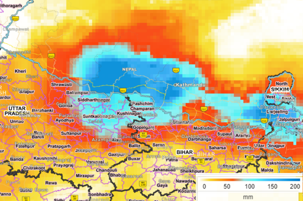
Fig-1 Heavy precipitation observed over Central and estern Nepal on September 27, 2024 from Global Satellite Mapping of Precipitation (GSMaP) (Source:Vedas)
The ongoing late September floods of 2024 especially along River Ganga and Kosi are no exception and further substantiate the fact that this is becoming a continuous trend. The floods have been triggered due to heavy torrential rains exceeding more than 200mm between September 26 and 28, 2024 in upper catchment areas in Nepal especially central and eastern parts (Fig-1). The heavy rains combined with the release of excess discharge from upstream barrages have led to anomalous flows and causing flooding and damages in downstream regions. Till September 27, 2024 most of the rivers in Bihar were flowing below danger level and only at four gauge sites along Ganga, Burhi Gandak and Kosi River were flowing above danger level and exhibiting a falling trend. However, the heavy rains led to increased flows in eight rivers i.e. Kosi, Bagmati, Mahananda, Gandak, Kamla Balan, Burhi Gandak, Parman and Ganaga Rivers causing 14 gauge sites located along them to be in high flood level situation. Since September 27 till October 01, 2024 these sites have been maintaining a rising trend leading to severe flood situation in downstream regions. Time series data acquired from satellite images validates the in-situ gauge data observations. From optical Sentinel-3 OLCI images the presence of persistence of cloud cover is observed over Nepal and Bihar between September 25 and 28, 2024 and from September 29 the thinning of cloud cover and subsequently the region becoming almost cloud free from October 02, 2024 is observed.
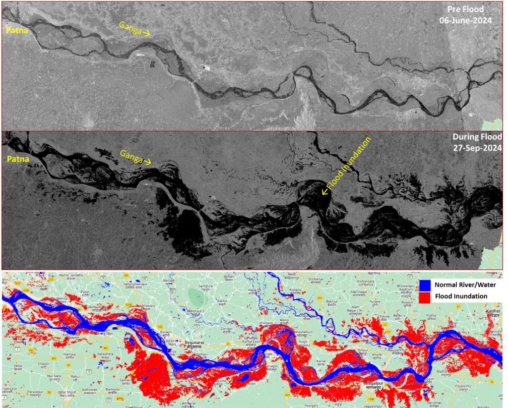
Fig-2 Flood inundation from Sentinel-1 before, after and flood extent along River Ganga as on Sept. 27, 2024.
Fig-2 shows the flooding changes before and during the floods along River Ganga captured from Sentinel-1 SAR images and mapped extent of inundation (red colour) as on September 27, 2024. Most of the water flowing down the rivers flowing from Northern Bihar and merging with Ganga has led to higher flows in Ganga. On October 02, 2024 sites especially located along Ganga River are observed to be maintaining a rising trend and being in high flood situation whereas others are either maintaining a falling or steady trend. The latest flooding situation as on October 02, 2024 is very clearly captured by Ocean and Land Colour Instrument (OLCI) on board Sentinel-3 satellites (Fig-3). The OLCI Earth Observation Full Resolution (EFR) dataset contains top of atmosphere radiances at 21 spectral bands with center wavelengths ranging between 0.4µm and 1.02µm at spatial resolution of 300m with worldwide coverage every ~2 days. October 02, 2024 the inundation severity along major rivers in northern Bihar is very clear (Fig-3). High temporal resolution of OLCI holds the potential for continuous mapping and monitoring of floods.
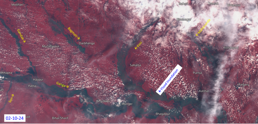
Fig-3 Flood condition in Bihar as on October 02, 2024 from Seninel-3 data.
The triggering of floods especially around late September and prolonging till October indicates a changing flood pattern and hence also necessitates preparing for better flood mitigation strategies like adopting to newer cropping patterns and controlling spread of water borne diseases.
References:
Bhatt, C. M., Amitesh Gupta, Arijit Roy, Prohelika Dalal, and Prakash Chauhan. “Geospatial analysis of September, 2019 floods in the lower gangetic plains of Bihar using multi-temporal satellites and river gauge data.” Geomatics, Natural Hazards and Risk 12, no. 1 (2021): 84-102.
Pai, D.S., Arti, B., Sunitha, D., Madhuri, M., Badwaik, M.R., Kundale, A.P., Sulochana, G., Mohapatra, M. and Rajeevan, M., 2020. Normal dates of onset/progress and withdrawal of southwest monsoon over India. Mausam, 71(4), pp.553-570.