
On 28th March 2025, a major earthquake of magnitude 7.7 Mw hit Central Myanmar near Mandalay city at 12:50 Hrs local time (GMT + 6:30 hrs). The epicentre of the earthquake (21°59’46.68″N/95°55’32.88″◦E) is located 14.2 km NNW of Sagaing town in the Sagaing region and approximately 16 km west of Mandalay city, the second-largest city in Myanmar. The earthquake occurred due to the strike-slip motion at a depth of 10 km (USGS, 2025). The tectonic activity in Myanmar is primarily governed by an oblique subduction of the India Plate under the Burma Plate resulting from the combined northward movement and eastward subduction of the India Plate. The ~1200 km long dextral strike-slip Sagaing Fault accommodates most of the impact of oblique subduction (Mon et al., 2020; Panda et al., 2018) and is the region’s major causative fault for seismic activity. An exceptionally long surface rupture of ~500 km was observed on satellite data (Bradley and Hubbard, 2025). By pixel-tracking of Sentinel-1 and Sentinel-2 pre-event and post-event images, the earthquake slip at the surface was found to be >3 m along the major parts of the rupture and 4-5 m around the epicentre. It has been considered one of the most powerful rare types of ‘supershear’ earthquakes in this region in which the rupture moved exceptionally faster than the seismic shear wave velocity (ANSS, 2025; Witze, 2025). Consequently, it amplified ground acceleration and caused widespread damage across Myanmar and, to a lesser extent, in neighbouring countries such as Thailand, Vietnam and China.
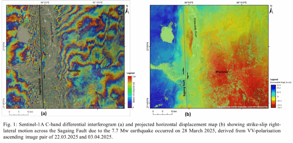
Using the C-band SAR Sentinel 1A ascending pass data pair acquired on 22.03.2025 and 03.04.2025, we have generated a VV-polarisation differential interferogram of the IW1 sub-swath showing prominent right-lateral (dextral slip) land surface displacement pattern (Fig. 1a). From the offset of the fringe pattern and temporal decorrelation along the Sagaing Fault, the earthquake rupture could be clearly identified. We generated a RADAR LOS displacement map from the differential interferogram and projected it to horizontal lateral displacement across the Sagaing Fault rupture (Fig. 1b). The western part of the Sagaing Fault rupture has moved 31.5 cm towards the north whereas the eastern part moved 31.5 cm towards the south. For the entire IW1 subswath, we observed the maximum northward and southward displacement of the western and eastern blocks >50 cm each, which gave rise to a total right-lateral strike-slip displacement of >1 metre due to the earthquake. However, due to the temporal decorrelation of some parts of the study area (e.g., Irrawaddy River and dense forest areas), some displacement fringes were missed, which led to an underestimation of the results.
References:
ANSS, 2025. M7.7-16 km NNW Sagaing, Myanmar, Comprehensive Catalog. U.S. Geological Survey.
Bradley, K., Hubbard, J.A., 2025. Surface ruptures of the Myanmar M7.7 earthquake mapped from space. Earthquake Insights. DOI: 10.62481/51b7df8c.
Mon, C.T., Gong, X., Wen, Y., Jiang, M., Chen, Q.F., Zhang, M., Hou, G., Thant, M., Sein, K., and He, Y., 2020. Insight into major active faults in Central Myanmar and the related geodynamic sources. Geophysical Research Letters, 47, e2019GL086236. DOI:10.1029/2019GL08623
Panda, D., Kundu, B., Gahalaut, V.K., Rangin, C., 2018. Crustal deformation, spatial distribution of earthquakes and along strike segmentation of the Sagaing Fault, Myanmar, Journal of Asian Earth Sciences, 166, 89-94. DOI: 10.1016/j.jseaes.2018.07.029.
Witze, A., 2025. Deadly Myanmar earthquake was probably a rare rupture, scientists say, Nature, 640(8058), 296-297.
No Comments