


Manu Mehta and Akhilesh Kumar
Estimating atmospheric aerosol levels is crucial for accurate radiative forcing calculations, understanding aerosol effects on cloud formation, assessing human health impacts, and planning pollution control. Continuous monitoring of aerosols in both space and time is essential to understand its effects in human life. Ground-based networks like AERONET and ARFINET use instruments such as sun-photometers and radiometers to measure optical parameters accurately, but their spatial coverage and variability is limited. Satellite-based Remote Sensing offers a solution by providing repeatable measurements over large areas and time periods, despite some uncertainties.
Retrieving aerosol data from satellite signals involves solving radiative transfer equations, which can be time-consuming, especially at high spatial resolutions. Traditional algorithms use Look-Up Tables (LUTs) to speed up this process, but this approach can be computationally intensive. Recently, new algorithms have been developed to balance accuracy with reduced complexity and faster retrieval speeds (Bilal et al., 2013; Seidel et al., 2012).
The latest study at Indian Institute of Remote Sensing (IIRS), ISRO, focuses on retrieving aerosol optical depth (AOD), which is an indicator of aerosol levels from satellite data (Kumar and Mehta, 2023). The algorithm was tested using data from the Operational Land Imager (OLI) on Landsat 8 satellite data and the Multispectral Imager (MSI) on Sentinel 2 satellite data. The performance was evaluated over various surface types and validated against data from 18 AERONET sites across a wide geographic area. The study also compared the results with Moderate Resolution Imaging Spectroradiometer’s (MODIS) combined DBDT (MYD04_3K) operational products. The findings show that the algorithm performs well, with strong statistical and spatial agreement with AERONET and MODIS AOD products.
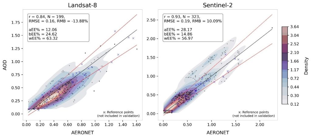
Above figure shows the density scatterplots of the retrieved and AERONET AOD at 550nm for 18 sites from (c) Landsat 8 and (d) Sentinel 2. Solid black line is 1:1 line and red solid lines are upper and lower Expected error (EE) lines. AERONET sites used as reference have been marked with a cross (x) and have not been included for validation or calculating associated statistics.
References
Bilal, M., Nichol, J.E., Bleiweiss, M.P., Dubois, D., 2013. A Simplified high resolution MODIS Aerosol Retrieval Algorithm (SARA) for use over mixed surfaces. Rem. Sens. Environ. 136, 135–145. https://doi.org/10.1016/j.rse.2013.04.014
Kumar A. and Mehta M., 2023. Investigating the applicability of a simple iterative approach for aerosol optical depth (AOD) retrieval over diverse land surface types from Landsat 8 and Sentinel 2 using visible and near- infrared (VNIR) spectral bands, Atmospheric Environment, 314, 120082. https://doi.org/10.1016/j.atmosenv.2023.120082
Seidel, F., Kokhanovsky, A., Schaepman, M.E., 2012. Fast retrieval of aerosol optical depth and its sensitivity to surface albedo using remote sensing data. Atmos. Res. 116, 22–32. https://doi.org/10.1016/j.atmosres.2011.03.006