

Introduction of irrigated rice in the semi-arid northwest Indian region is one the major changes in Indian agriculture. Punjab and Haryana has witnessed significant change in cropping pattern during the last few decades. Increase in rice area is of particular significance. The State of Punjab occupies a special place in Indian agriculture. Rice- wheat rotation followed in Punjab leaves little time for land preparation for wheat after rice. This require early transplanting of rice using irrigation from ground water.
These states receive less annual rainfall compared to the national average. Rice, a water loving crop, requires a large amount of water for its growth and development which rainfall alone cannot meet. Thus, conjunctive utilization of water (mainly ground water and rainfall-based irrigation) is being practiced in the region. Over exploitation of groundwater (GW) in the recent past is a well-known fact for the Punjab and Haryana region of India. This decline in GW has enforced the Punjab Preservation of Sub-Soil Water Act 2009. This policy resulted in overall two-week relative shift (delay) in irrigation practices in the pre- and post-Water Act implementation.
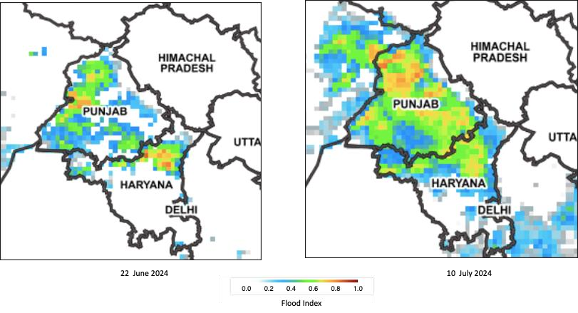
Figure 1: Surface flooding condition mostly due to rice transplantation observed from passive microwave radiometer on 22 June 2024 and 10 July 2024 over Punjab and Haryana region, India.
It is well known that satellite remote sensing in optical wavelengths is more sensitive to vegetation cover, while microwave remote sensing can detect surface soil-moisture conditions. Microwave radiometers (e.g. AMSRE, AMSR2) record emission from Earth’s surface and atmosphere to estimate Brightness Temperature at multiple frequencies and retrieve a variety of geophysical parameters. The figure 1 shows assessment of regional-scale surface flooding using Brightness Temperature of 36.5 GHz from AMSR-2 data in June and July months of 2024. Microwave Polarization Difference Index (MPDI) was used to identify flooded pixels. We can see surface flooding due to rice transplanting on 22 June 2024 in parts of Punjab and Haryana. Surface flooding further increased to other areas including neighboring region of Pakistan on 10 July 2024. This visualization is based on near real-time Flood Index product available on VEDAS web portal (http://vedas.sac.gov.in).
Article is contributed by Raghavendra P. Singh, IIRS, ISRO, Dehradun. Contributions of Shri Shashikant Sharma, Rohit Pradhan, Nimisha Singh and Dr. P. K. Gupta of Space Applications Centre, ISRO Ahmedabad is thankfully acknowledged for providing Hydrological products on VEDAS Web portal.
References
- Pradhan, R., Singh, N., and Singh, R.P. (2021), Assessment of surface flooding over India from passive microwave radiometer, Journal of Geomatics, 15 (2), 258-262.
- Singh D., Gupta P.K., Pradhan R., and Singh R.P., (2017), Discerning Shifting Irrigation Practices from Passive Microwave Radiometry over Punjab and Haryana. Journal of Water and Climate (doi: https://doi.org/10.2166/wcc.2016.122 , 303-319.
- Singh RP, Dadhwal VK (2003) Comparison of space-based Microwave Polarization Difference Index (MPDI) and Normalized Difference Vegetation Index (NDVI) for crop growth monitoring. Indian J. Radio Space Physics, 32,193-197.
- Singh RP, Oza, SR and Pandya MR (2006), Observing long term changes in rice phenology using NOAA-AVHRR and DMSP-SSM/I satellite sensor measurements in Punjab, India. Current Science, 91 (9), 1217-1221.
- Oza SR, Singh RP, Dadhwal VK and Desai PS (2006), Large area soil moisture estimation and mapping using space-borne multi-frequency passive microwave data. J. Ind. Soc. Remote Sensing. 34 (4), 343-350.