 Ashish Joshi ,
 Shefali Agrawal ,
 Raghavendra P Singh |
August 3, 2026 |
301 Views |
0 Comments
|
Raghavendra P Singh |
August 3, 2026 |
301 Views |
0 Comments
| 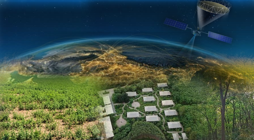
What if a satellite could detect a water-logged surface beneath the dense forests, which is invisible to ordinary optical cameras? A new Radar Imaging Satellite, NASA-ISRO Synthetic Aperture Radar- NISAR, is making this possible, helping scientists and researchers to understand the forests, wetlands, vegetation, and environmental changes in a completely new way.
NISAR is an exciting new Earth-observation satellite mission developed jointly by NASA and ISRO to better understand our changing planet. Unlike optical satellites that capture pictures using sunlight, NISAR uses advanced radar technology called Synthetic Aperture Radar (SAR), allowing it to observe earth day and night, even penetrating through clouds. With this technology, scientists can track subtle environmental changes, including shifting ground after earthquakes, changing forests, expanding wetlands, evolving agricultural landscapes, and glaciers.
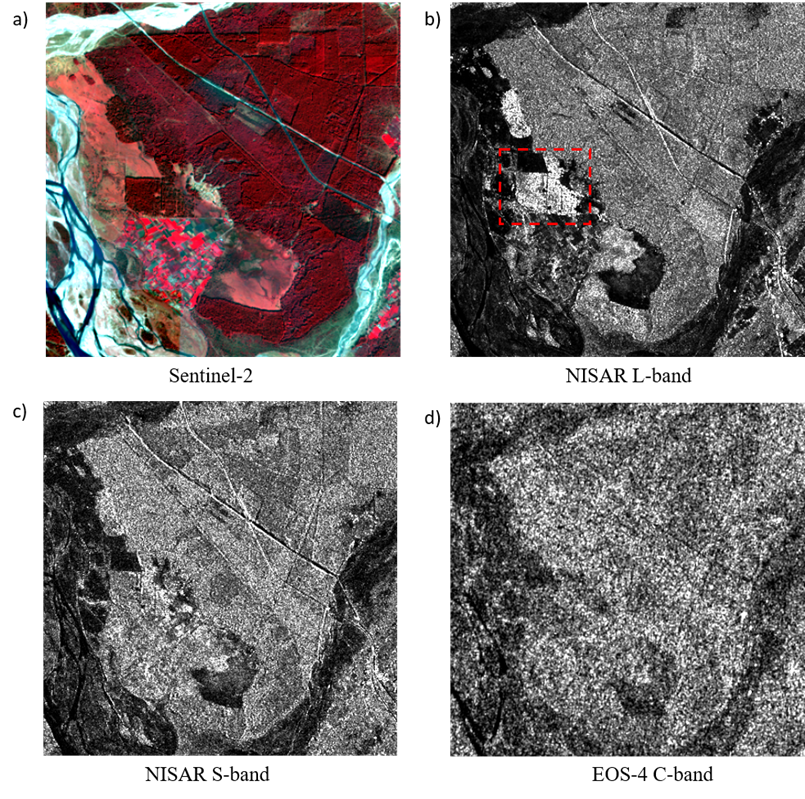
Figure1: Comparative Analysis of Optical & SAR observations a) Sentinel-2 image b) NISAR L-band Image (HH) c) NISAR S-band Image (HH) d) EOS-4 C-band Image (HH)
Imagine trying to map a dense forest from space. To a standard camera, all you see is a solid, bright green blanket of leaves. The trick is to use different wavelengths, which can penetrate the forest at different penetration depths. What makes NISAR unique is that it is the world’s first radar satellite mission using two radar wavelengths together, L-band and S-band. To map a forest from space, NISAR uses two different flavours of radar wavelengths to slice through the forests like an X-ray machine. Shorter S-band waves penetrate into the upper-to-mid forest canopy, and longer L-band waves act as deep divers, piercing straight through the dense canopy to map hidden flood waters and soil moisture on the forest floor.
To understand how this technology can help monitor wetlands and forests, an ecologically important region called Jhilmil Jheel wetland , near Haridwar in Uttarakhand, India, has been studied. Situated in the Himalayan foothills, this landscape is rich in dense forests, wetlands, and diverse vegetation. Seasonal flooding and changing water conditions make it an ideal natural laboratory for testing how radar satellites observe hidden flooded and moist forests.
Using radar images collected by NISAR in January 2026, observations from L-band and S-band radar systems were studied. Optical imagery from Sentinel-2 and radar observations from India’s EOS-04 C-band SAR satellite to better understand how different sensors observe the same environment. The Sentinel-2 false colour composite (FCC) image is presented in figure 1(a), while the HH polarization images of NISAR L-band, NISAR S-band, and EOS-04 C-band are shown in figures 1(b), 1(c), and 1(d), respectively.
The findings revealed something remarkable. Forests associated with wetlands along the river Ganga appeared much brighter in NISAR’s L-band radar images than in S-band and C-band observations.
Why? Because L-band radar waves are better at penetrating tree cover and reaching waterlogged surfaces hidden below.
When radar signals strike water-logged forests, they bounce between tree trunks and the water-covered ground underneath before returning to the satellite (Figure 2). This is called “double-bounce scattering” .This effect produces stronger radar reflections in the form of bright patches, allowing wetland forest areas to stand out more clearly in the images.These “bright patches” are highlighted in Figure 1(b) within the red box.
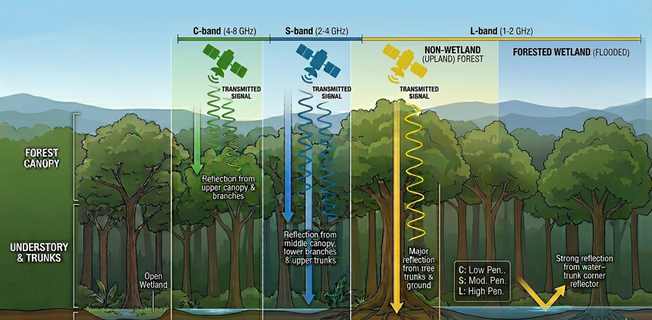
Figure 2: Scattering mechanisms of different Radar Frequency inside forest canopy (Source : AI generated)
By contrast, shorter radar wavelengths, such as S-band and C-band, interact mainly with the upper canopy to mid canopy of the forest. Since they cannot penetrate as deeply, they are less sensitive to hidden wetland conditions beneath dense vegetation.
NISAR, being a multifrequency SAR, provides a more complete picture of forests. While L- band frequency reveals what is happening beneath the forest canopy, the other captures details of the vegetation structure above. Together, it helps to distinguish between wetland forests and surrounding non-wetland forests with greater accuracy.
Radar images also displayed different colour patterns that helped to identify different features on the Earth’s surface. Wetland forests appeared in bright red and pink shades in L-band radar composites, signalling strong interaction between tree trunks and water-logged ground. These red and pink shade patches are highlighted in Figure 3 within the red box.
These findings demonstrate how NISAR’s dual-frequency radar system can improve our understanding of complex ecosystems. By revealing hidden waterlogged and moist environments beneath forests, the satellite mission can support better wetland conservation, biodiversity monitoring, and environmental management.
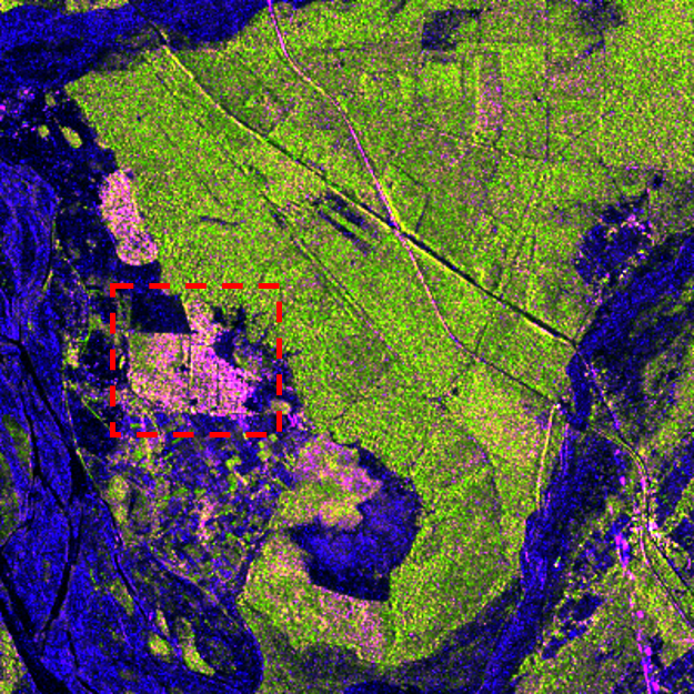
Figure-3: NISAR L-band Polarimetric RGB composite (HH-R, HV-G, HH/HV-B)
References :
- https://www.isro.gov.in/NISARSatellite.html
- P. A. Rosen et al., “The NASA-ISRO SAR Mission: A summary,” in IEEE Geoscience and Remote Sensing Magazine, doi: 10.1109/MGRS.2025.3578258.
- Joshi A. (2025), https://science.iirs.gov.in/nisar-beginning-of-a-new-era-of-spaceborne-dual-multi-frequency-sar-missions/
No Comments