Life of earth is linked to availability of water and rivers provides water to sustain the human civilization. Ganga river is one of the longest river in India and is associated with sediment transport and meandering. Ganga river originate in the Himalayas, and it carries lot of sediments. Sediment deposition prevent any river from flowing straight and cause meander. Gandak river, a tributary of Ganga has origin in Nepal. It flows southeast across Gangetic plain of Bihar state and joins the Ganga near Patna just downstream of Hajipur. Over years Gandak river has undergone lateral erosion resulting in changes in course of its flow. Meandering of river and its changes are monitored using satellite data for better management of flood and agricultural practices. We can see the systematic changes in the course of Gandak river near Gapalganj over more than three decades (fig.1).
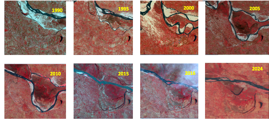
Figure 1: Changing course of Gandak river in Bihar, India observed using false colour composite of Landsat and Resourcesat-AWiFS data during month of April from 1990 to 2024.
Images of April month of Landsat and Resourcesat AWIFS data spanning from 1990 till 2024 is shown in figure 1 and formation of loop like shape can be noticed in Gandak river due to meandering. River meanders are natural process which bends the river course. Meandering river erode the sediment from outer curve of each meander and deposit it in the inner curve downstream. The changes in course of river leads to the widening of river channel and flood plains are formed along riverbanks. It can be seen in above figure 1 that fertile soils of abundant fluvial channel and its floodplains is beneficial for agriculture in terms of increase in vegetation diversity and vigour. However lateral migration of meanders is harmful to infrastructure located near riverbanks. Understanding and monitoring of changes in course of river is important for effective land – use planning and flood management.
Article is contributed by Raghavendra P. Singh, IIRS , ISRO, Dehradun. Visualization of Resourcesat- AWiFS of April 2024 is based on VEDAS web portal (http://vedas.sac.gov.in) .